Sunday, August 31, 2008

Barack Obama and Nelson Mandela

Barack Obama and Nelson Mandela: Two Black Eyed Peas in a Pod

Barack Obama has mesmerized the masses with his mantra of "Change We Can Believe In" as terrorist Nelson Mandela fooled folks with his snake oil of "A New South Africa".

Educate yourself about harsh reality, don't be fooled by pretty platitudes, and beware such wolves in sheep's clothing, such Black racists pretending to be color-blind, such Marxist preachers abusing useful idiots to aid and abet them.
*******

OBAMA'S 'CHANGE WE CAN BELIEVE IN': REPACKAGED FAILED POLICIES


The New South Africa
blog attempts to chronicle the extreme violence and secret genocide being committed against the white minority of South Africa. Tens of thousands of whites have been murdered since 1994. Brutal torture and rape is common and not even the young or elderly are spared.


http://www.dienuwesuidafrika.com | http://www.farmmurders.com | http://www.plaasmoorde.com

There Goes The Nation

It's A Sin To Vote For Obama!

Friday, August 29, 2008

South Africa Ruled By Barbarians, America Next?

And ignorant and naive Americans want to vote Obama into power, a Black Supremacist who was indoctrinated by Black racist preacher Jeremiah Wright for over 20 years and only recently distanced himself for political purposes? Because Obama has "learned to talk to White people"? Because Obama has learned how to pull the wool over their eyes! Useful idiots, a danger to themselves and others.

South Africa Ruled By Barbarians, America Next?

Wednesday, August 27, 2008

Native Americans Against Obama For Good Reasons

Mike Graham (Founder, United Native America)

The more Obama talks about "Change", Native Americans see "No Change Nor Commitment" for them with Obama as president.
Native Americans Against Obama For Good Reasons

Spider Rock, Canyon de Chelly (de Shay)

Spider Rock, in Arizona's Canyon de Chelly (de Shay), is considered sacred to the Navajo and is associated with Spider Woman who taught the Dineh (Navajo) how to weave. Navajo legend says Spider Woman lives on top of Spider Rock.

Spider Rock is an "800 foot sandstone spire that rises from the canyon floor at the junction of Canyon de Chelly and Monument Valley" (visit National Park Service - Canyon de Chelly for more information).

Earlier I had visited Monument Valley and Four Corners (where I was able to give a copy of my book, Beyond Babylon, to a very nice and friendly, spirited, Navajo woman) and was eager to see Canyon de Chelly (de Shay is how it's pronounced, so why don't they just spell it that way?) but hoped to take a shower first, but the public shower (available for Navajo normally) wasn't available due to elections that day, naturally, with the area filled with politicians.

Thankfully, Thunderbird Lodge at the beginning of the canyon graciously let me use their internet in their lobby (for free) to email family and friends I was fine. Then I went and visited the entire North Rim Drive (4 overlooks - 34 miles round trip) and South Rim Drive (7 overlooks - 37 miles round trip), every designated scenic stop and spot, and towards the end was rushing against the setting sun to finish seeing all of the spectacular views. Mission accomplished!

Here are a few of my precious photos there of what God blessed me to see and enjoy. Remember to click on them to enlarge them. They are immediately followed by a slideshow of Canyon de Chelly as I saw it!


Special thanks to ImageShack for Free Image Hosting :- )

Tuesday, August 26, 2008

Does The Bible Teach There Were Human Prototypes?

Questions about ancient peoples, even cavemen, possible human prototypes, were brought up in my mind since I've just returned from visiting the Navajo Nation and regions known to Comanche, Ute, Cheyenne, Kiowa nations/tribes (Monument Valley, Canyon de Chelly, Four Corners, Palo Duro Canyon, Washita River Battlefield, etc.), and because of a recent discovery in the Galilee mentioned in Israel National News, which prompted me to write a rabbi friend, Yehoshua, in Israel.

Does The Bible Teach There Were Human Prototypes?

Monday, August 25, 2008

Jerusalem speaks to Hinton's heart

Gershon Salomon came from Jerusalem to what he said (with a smile) felt like "the ends of the Earth" - Hinton, West Virginia. It is beautifully described on Hinton's official website as a place, "Woven into the mountains of Appalachia, along the scenic New River in Southern West Virginia...."

Jerusalem speaks to Hinton's heart

Monday, August 18, 2008

People of White Color

Originally Posted by Merrygold View Post
I don't hate white people .


So you're in denial? Your posts against White people appear to prove otherwise.


Quote:
What I do detest are the numerous comments that you've posted claiming white supremacy over anyone of color


Again, typical politically correct double standards, reverse discrimination, glaring hypocrisy - "anyone of color." How racist! Don't you realize WHITE is a COLOR? White people are people of WHITE color. To get technical, black is actually the absence of color!

As far as White supremacy goes, it should go without saying to honest folks. Why do you detest THE PLAIN TRUTH? To which countries do folks clamor to emigrate? Black Africa? Asia? Mexico? What race of people have created more inventions enjoyed by folks of every color and creed? Arts? Literature? CIVILIZATION. THINK about it.

Quote:
including those of us of Native American descent
I mentioned to the descendant of Cheyenne Peace Chief Black Kettle how the various "First Nations" were brutally at each others' throats and weren't living in peace and harmony before the militarily superior White tribes came and conquered them all. Why vainly deny these FACTS? Why should facts disturb folks? Because such folks are racist against White people! THINK about it.

Quote:
while spouting Scripture mingled with Fred Phelps - style propaganda .
Spouting? Prejudicial use of propaganda language there, but the facts remain the same that I dare to share the plain truth of the Bible and history and it doesn't sit too well with those who prefer their darkness.

Quote:
Not interested in your pictures
Your prerogative and loss.

It's rather revealing that instead of appreciating I've posted something that could put White Israelites in a bad light (although I've stated we're sinners like others but God's Purpose goes forward), I've helped publicize Black Kettle and the controversy surrounding his death, a few have chosen to ignore all that and go on the warpath over imagined injustices. So much for peace and reconciliation!

The English-Speaking Nations of White Israelites

www.DavidBenAriel.org

Sunday, August 17, 2008

Canyon de Chelly National Monument

Excerpt from National Park Service - Canyon de Chelly


QUICKLINKS:


Canyon de Chelly National Monument

Reflecting one of the longest continuously inhabited landscapes of North America, the cultural resources of Canyon de Chelly include distinctive architecture, artifacts, and rock imagery while exhibiting remarkable preservation integrity that provides outstanding opportunities for study and contemplation. Canyon de Chelly also sustains a living community of Navajo people, who are connected to a landscape of great historical and spiritual significance. Canyon de Chelly is unique among National Park service units, as it is comprised entirely of Navajo Tribal Trust Land that remains home to the canyon community. NPS works in partnership with the Navajo Nation to manage park resources and sustain the living Navajo community.

The Great Sand Dunes are not a mirage!

I recently returned from seeing the Great Sand Dunes en route to Four Corners from Toledo, Ohio! I had never heard of them before, but when I stopped to read the historical information sign near Alamosa in San Luis Valley, Colorado about Mount Blanca, the first of the four sacred mountains to the Deneh/Navajo (and in the Navajo language Mount Blanca is called Tsisnaasjini' - Dawn or White Shell Mountain), I noticed the sign mentioning the Great Sand Dunes and decided to go check them out and was hoping they wouldn't be a waste of time and gas money - and they definitely weren't! I would love to have spent more time there, and was sure glad I was there early in the morning so I could climb on them before it got too hot (and the altitude certainly affected me too), and I saw my first Pronghorn Antelope there, but I continued to Four Corners, Monument Valley, Canyon de Chelly (de shay), etc.

Click on images to enlarge them.


Free Image Hosting at www.ImageShack.us

Free Image Hosting at www.ImageShack.us

Free Image Hosting at www.ImageShack.us

Notice the little specks half-way up on the right? They're people!

After leaving the Great Sand Dunes and winding through the beautiful Wolf Creek ski area of Colorado, through the Rio Grande National Forest, another pleasant surprise greeted me near Pagosa Springs: Treasure Falls.


Free Image Hosting at www.ImageShack.us

Free Image Hosting at www.ImageShack.us

Thanks to ImageShack for Free Image Hosting

Black Kettle Bridge or Massasoit Boulevard?

Cheyenne Peace chief Black Kettle is believed to have worked for peace among the Indian tribes and our White Israelite tribes. As I mentioned to his descendant while visiting the Washita Battlefield National Historic Site in Oklahoma, it's disgusting to see Martin Luther King and Communist Rosa Parks' names littered across the United States on bridges, boulevards, ad nauseam, and that if we truly wanted to honor those who sought peace and proper understanding between our respective tribes, our diverse peoples, we should have things named after Massasoit (sought peace between Indians and pilgrims) or other truly worthy folks, not documented frauds.

Friday, August 15, 2008

Reflections on Washita Battlefield National Historic Site

Washita (excerpt from http://www.nps.gov/waba)
The site protects and interprets the setting along the Washita River where Lt. Col. George A. Custer led the 7th U.S. Cavalry on a surprise dawn attack against the Southern Cheyenne village of Peace Chief Black Kettle on November 27, 1868. The attack was an important event in the tragic clash of cultures of the Indian Wars era.

************

God did promise the Promised Land of Israel to all Twelve Tribes of Israel, presently held in trust by Judah (the Jews). And Manifest Destiny declared these "Lands of the Covenant" (USA in Hebrew/Artzot Habrit) were designed to become the inheritance of Manasseh, the son of Joseph and other Israelites primarily, and the same goes for the British-Israelite company of nations, commonwealth of nations.

I've been out to our American Southwest recently, and I enjoyed a wonderful discussion with a descendant of Cheyenne chief Black Kettle at the Washita River site where he was killed with his wife, Medicine Woman Later - both having survived the Sandy Creek Massacre - and when I asked her where she thought the Indians came from, even mentioning how I write on forums I'm a Native American (since I was born here), she said from the Bering Strait and that they've heard they probably have relatives up there!

I honestly said how I refer to Indians as Beringian immigrants, and unlike some self-hating and self-righteous White people on the internet, she didn't have a problem with anything I said!

When she pronounced the Cheyenne name for her people for me, she mentioned how it means "the People." I said folks would have a fit if White people referred to themselves as "the People" or as La Raza (the Race); She agreed the Indians fought among themselves before and after the White tribes came that were militarily superior and conquered them all; She also agreed God will settle these issues and put us all in our proper place when Yeshua returns, after I mentioned I believe the Bible reveals God divided the nations, separated the peoples, for His Supreme Purpose.


****************

The impressive Washita National Park Visitor Center offers folks a chance to share Visitor Perspectives. This is what I wrote:

These "Lands of the Covenant" (Artzot Habrit is Hebrew for USA) were destined to become the inheritance of Manasseh, the son of Joseph. However, the way we received our birthright and blessing, like Jacob who deceived his father Isaac, hasn't always been so honorable.

My spirit grieves for injustices suffered by both Beringian immigrants (American Indians) and White Israelites (Anglo-Saxon-Celtic and Northwestern European peoples).

David Ben-Ariel,
Toledo, Ohio, USA

Click on images to enlarge them.

Washita Battlefield


Washita Battlefield

Thanks to ImageShack for Free Image Hosting

Wednesday, August 13, 2008

National Cowboy and Western Heritage Museum (Oklahoma City)


[The following excerpts are from the National Cowboy & Western Heritage Museum's website].


The National Cowboy & Western Heritage Museum is America’s premier institution of Western history, art and culture. Founded in 1955, the museum in Oklahoma City collects, preserves and exhibits an internationally renowned collection of Western art and artifacts while sponsoring dynamic educational programs and ground-breaking scholarly research to stimulate interest in the enduring legacy of our American West. More than 10 million visitors from around the world have sought out this unique museum to gain better understanding of the West: a region and a history that permeates our national culture.

Home
Information
Events
Collections
Education
Involvement
Research Center
Store
About The Museum
Awards & Halls of Fame
Planning a Visit
Facility Rentals
Employment & Internships
Media
Contact Us
Restaurant


Prix de West Awards
Rodeo Hall of Fame
Chester A. Reynolds Awards
Ben Johnson Memorial Award
Tad Lucas Award
Great Westerners
Western Heritage Awards
Western Performers


General Rental Information
Special Events Center
S.B. "Burk" Burnett Board Room
Plaza & Gardens
Weddings & Wedding Receptions


Calendar of Events
Recent News
Annual Events


Chuck Wagon Gathering
Prix de West
Rodeo Weekend
Small Works, Great Wonders
Traditional Cowboy Arts Association
Western Heritage Awards


Permanent Galleries
Exhibitions
Curatorial Column
Research Center


School Field Trips & Programs
Adult Tours


Corporate Partners
Become a Member
Make a Donation
Planned Gift
Persimmon Hill Magazine
Volunteer Programs

E-Newsletter


CALENDAR
DONATE
CONTACT US
JOIN
SEARCH
Home

Information

Events

Collections

Education

Involvement

Research

Store
Email Us
National Cowboy & Western Heritage Museum1700 NE 63rd St, Oklahoma City, OK 73111 (405) 478-2250
**********

A few of my photos:


Coleman Theater (Miami, Oklahoma)

[The following are excerpts from the Coleman Theatre website]

Welcome to the Coleman Theatre Beautiful Miami, Oklahoma!


From opening day April 18, 1929 with a full house of 1,600, the Coleman Theatre Beautiful has never been "dark". Since the Coleman family donated the historic structure to the City of Miami in 1989, restoration and renovation of the theatre has become a "labor of love" in the community.

Begin your virtual tour in Act I - The Beginning and browse throughout this site to learn about our Coleman and how you can become a part of it. You may also request information about various events and programs or join the restoration effort. We're located at 103 N. Main St., Miami, Oklahoma 74354. Check out our Photo Gallery!

http://colemantheatre.org/

****************

I was able to take a tour of the Coleman Theatre this summer during a trip out West. I was almost out of Oklahoma and wanted to mail some postcards, so at the post office in Miami, practically on the borders of Kansas and Missouri, I mailed them and asked what was there to see in Miami. They told me the Miami Theatre and pointed toward it just a block or so away. So away I went to go check it out. Here are a few of my pictures:


Cahokia Mounds State Historic Site

Cahokia Mounds State Historic Site, administered by the Illinois Historic Preservation Agency, is located just eight miles from downtown St. Louis at:30 Ramey Street, Collinsville, IL 62234
Hours of OperationInterpretive Center: Wednesday through Sunday 9am to 5pmGrounds: 8am to dusk

Full details and Holiday Schedule


Welcome
Visitor Info
Calendar of Events
Site Tour
Interpretive Center
Archaeology
Teaching Resources
Museum Society
Gift Shop
Volunteer
Related Links
Search Site


-->

Washita Battlefield National Historic Site (U.S. National Park Service)

QUICKLINKS:
Directions
Operating Hours & Seasons
Fees & Reservations
Centennial Initiative 2016
Washita
The site protects and interprets the setting along the Washita River where Lt. Col. George A. Custer led the 7th U.S. Cavalry on a surprise dawn attack against the Southern Cheyenne village of Peace Chief Black Kettle on November 27, 1868. The attack was an important event in the tragic clash of cultures of the Indian Wars era.


New Park Visitor Center
Come see our new visitor center and learn more about the clash of cultures between the U.S. Army and the Southern Cheyenne in 1868.
more...


A Message from Superintendent Wendy Lauritzen
Dear Friend:
I am writing to inform you of the status of park operations, upcoming special activities and enhanced programs at Washita Battlefield National Historic Site. As many of you know, we held our “Ribbon Cutting for the Grand Opening” of the visitor center on April 20, 2007. more...


History Day News
Click Here to view a slideshow from the History Day activities on Saturday, November 17, 2007.
Washita Battlefield NHS News ReleasePark Announces History Day Schedule for Saturday, November 17 Activities at New Visitor CenterClick "more..." to read entire press release.more...


Write toRt.1 Box 55a Cheyenne, Oklahoma 73628
E-mail Us
PhoneHeadquarters(580) 497-2742
Fax(580) 497-2712
ClimateThe Historic Site has a continental climate characterized by cool winters and hot summers with large variations from day to day. Annual precipitation is approximately 23 inches. Strong winds accompany the passages of cold fronts. Temperatures can be anywhere from less than 0°F in the winter and highs are capable of reaching more than 100°F in the summer months. Elevation is approximately 2,000 feet. Humidity can be high. We suggest bringing clothes for any occasion.


Did You Know?Washita Battlefield National Historic Site is building a new Cultural Heritage Center. Here, the late fall sun

Sandia Peak Tramway (Albuquerque, New Mexico)

http://www.sandiapeak.com/

A trip on the world’s longest aerial tramway transports you above deep canyons and breathtaking terrain a distance of 2.7 miles. See some of nature’s more dramatic beauty unfold before you. At sunset the desert skies produce a spectacular array of color, and your vantage point from the observation deck atop 10,378 foot Sandia Peak in the Cibola National Forest affords an 11,000 square-mile panoramic view of the Rio Grande Valley and the Land of Enchantment. Located on the eastern edge of Albuquerque in the Sandia Foothills at the end of Tramway Road.


Interesting links:

A brief history of the Albuquerque Tram

statistics fact-sheet on the Tram (pdf)

Virtual Sandia Peak Tramway


http://www.sandiapeak.com/

*****************

Here's a few of my pictures taken this summer (2008)...


Blue Hole, New Mexico (Santa Rosa)

I had never heard of any Blue Hole in New Mexico until traveling from Sandia's Peak in Albuquerque through Santa Rosa (that seemed to have a loving and calm spirit of camaraderie) and asked a fellow at the local grocery store what there was to see in Santa Rosa and he suggested the Blue Hole first, and the Santa Rose Dam and Lake second (where I met two nice women who were in town for training or training others - something about the prison system). We have a Blue Hole in Ohio too.

My quick dip in the Blue Hole was refreshing and I had the whole place to myself, since the few kids who were hanging out for awhile took off, and I noticed walking around the perimeter of the site that somebody left their flip flops behind and somebody else left a quart of opened milk standing on the ground half full, even though a trash can was nearby. The place looks somewhat neglected but has plenty of potential. (I returned to thank the fellow but he was gone and left one of my Beyond Babylon cards - resembles my book cover, name, email and website addresses - with the girl still working who said she would give it to him with my thanks).


Blue Hole, Santa Rosa, New Mexico
559 x 420 - 67k - jpg
www.glasmann.org
New Mexico
1024 x 768 - 414k - jpg
www.jhepple.com

Treasure Falls, CO


Treasure Falls, CO
335 x 500 - 151k
flickr.com
... a section of Treasure Falls, CO.
500 x 334 - 138k
flickr.com

Treasure falls takes its name from Treasure Mountain. This area is rich in folklore and old stories of a large buried treasure somewhere on the mountain. Most accounts suggest that a fabulous treasure in gold was buried in the area after a group of Frenchmen were "waylaid" by either the Spanish or Indians. Whatever the circumstances, Treasure Falls offers the visitor a breathtaking treasure of scenery.

The falls can be seen by driving east on U.S. Hwy. 160 approximately 15.0 miles from the San Juan river bridge on the east side of Pagosa Springs. Along the highway there is a large parking area with a well maintained trail leading to the base of the falls. The walk up to the falls can be seen from the highway and there is a good opportunity to take photographs from the highway as well as from the overlook bridge at the base of the falls.

Directions from Pagosa Springs, Colorado: The falls can be seen by driving east on U.S. Hwy 160 approximately 15.0 miles from the San Juan river bridge on the east side of Pagosa Springs.

Seasonal Information:
Normally Accessible: Year-round.


Treasure Falls on the west side of ...
400 x 300 - 36k - jpg
megameladventures.blogspot.com

Treasure Falls in Pagosa Springs, ...
180 x 240 - 11k - jpg
www.sunset.com


Four Corners

The following is excerpts from the Navajo Nation's website:


FOUR CORNERS MONUMENT > hours & contact

flags

flags

four states

vendors

weather channel

Weather.com - See current temperature in
Teec Nos Pos, Az.
(Approx. 6 mi. from Four Corners Monument)


The Navajo Nation cordially welcomes you to one of our most unique landmarks - The Four Corners. This is the only place in the United States where four states intersect at one point: Arizona, New Mexico, Utah and Colorado. This location is very remote as you will experience when visiting.

The original marker erected in 1912 was a simple cement pad, but has since been redone in granite and brass. The Visitor Center is open year round, and features a Demonstration Center with Navajo artisans. Navajo vendors sell handmade jewelry, crafts and traditional Navajo foods nearby.

Picnic tables and self-contained restrooms are available. Services and accommodations are very limited to small cafes, grocery stores and self-service gasoline stations within a 30 mile radius.

We recommend that you have plenty of water, food, snacks, hand wipes and extra toiletries when visiting. The area is very remote, no running water, no electricity, no telephones.

Nearest Gas Stations : Teec Nos Pos,AZ - Shiprock,NM - Cortez,CO - Mexican Water, AZ - Bluff, UT

*Teec Nos Pos, Az. is the nearest community - approx. 6miles*

get directions using Mapquest.com

GENERAL INFORMATION
Open 8:00am - 5:00pm (Oct - May)
Open 7:00am - 8:00pm (June - Sept)

Admission $3.00 (all ages)

Four Corners Park Manager
PO Box 2520
Window Rock, AZ 86515
928.871.6647

email us

Great Sand Dunes National Park and Preserve


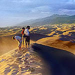
Hikers on Dunes

Dunes

Explore the tallest dunes in North America! Whether hiking, sliding, exploring in a dunes wheelchair - or simply playing - the Great Sand Dunes are a unique wilderness area protected for all to enjoy. Find out how these dunes were formed.
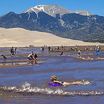
Girl Floating Medano Creek

Creeks and Streams

Water is the lifeblood of the Great Sand Dunes system. Streams begin as mountain snowfields, melting then flowing through alpine lakes, forests, dunes, grasslands, and lush wetlands. Explore the flowing waters of Great Sand Dunes. Check current conditions of Medano Creek .

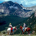
Horses on Music Pass

Mountains

Explore the mountain watershed of the Great Sand Dunes. Rugged 13,000' summits, alpine lakes, tundra, and ancient forests are protected in Great Sand Dunes National Preserve.
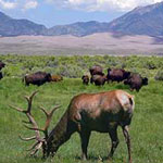
Bison and Elk on Grasslands

Grasslands, Shrublands, and Wetlands

Explore the grasslands, shrublands and wetlands that surround Great Sand Dunes on three sides.


Ranger program in Medano Creek

Did You Know?
Free ranger programs are offered regularly at Great Sand Dunes from May-September, and on request the rest of the year. Most programs welcome all ages.
more...

Monument Valley

the mittens
The Mittens

Navajo Name: Tse'Bii'Ndzisgaii
Elevation: 5,564' above sea level
Size: 91,696 acres
(extends into Arizona & Utah)

Welcome to the Navajo Nation's Monument Valley Park. You are experiencing one of the most majestic - and most photographed - points on earth.

This great valley boasts sandstone masterpieces that tower at heights of 400 to 1,000 feet. framed by scenic clouds casting shadows that graciously roam the desert floor. The angle of the sun accents these graceful formations, providing scenery that is simply spellbinding.
The landscape overwhelms, not just by its beauty but also by its size. The fragile pinnacles of rock are surrounded by miles of mesas and buttes, shrubs, trees and windblown sand, all comprising the magnificent colors of the valley. All of this harmoniously combines to make Monument Valley a truly wondrous experience. Enjoy this beautiful land.


Weather.com - See 10 day forecast in Monument Valley, UT

HISTORY
Before human existence, the Park was once a vast lowland basin. For hundreds of millions of years, materials that eroded from the early Rock Mountains deposited layer upon layer of sediments which cemented a slow and gentle uplift generated by ceaseless pressure from below the surface, elevating these horizontal strata quite uniformly one to three miles above sea level. What was once a basin became a plateau.

Natural forces of wind and water that eroded the land spent the last 50 million years cutting in to and peeling away at the surface of the plateau.

The simple wearing down of altering layers of soft and hard rock slowly revealed the natural wonders of Monument Valley today.

From the visitor center, you see the world-famous panorama of the Mitten buttes and Merrick Butte. You can also purchase guided tours from Navajo tour operators, who will take you down into the valley in jeeps for a narrated cruise through these mythical formations. Places such as Ear of the Wind and other landmarks can only be accessed via guided tours. During the summer months, the visitor center also features Haskenneini Restaurant, which specializes in both native Navajo and American cuisines, and film/snack/souvenir shop. There are year-round restroom facilities. One mile before the center, numerous Navajo vendors sell arts, crafts, native food and souvenirs at roadside stands.

the sisters
Three Sisters

Average Monthly Temp(F)


Min Max
JAN 25 43
FEB 26 47
MAR 33 54
APR 40 65
MAY 47 73
JUNE 58 85
JULY 63 90
AUG 62 88
SEPT 57 82
OCT 41 66
NOV 30 50
DEC 24 42

GENERAL INFORMATION: top of page
Monument Valley Navajo Tribal Park Visitor Center Hours
Summer (May-Sept) 6:00am - 8:00pm
Spring (Mar - Apr) 7:00am - 7:00pm
Thanksgiving Day - closed
Christmas Day - closed

Monument Valley Navajo Tribal Park Scenic Drive Hours
Summer (May-Sept) 6:00am - 8:30pm
Winter (Oct - Apr) 8:00am - 4:30pm

Entry Fees
Camping fees - $10/night plus Entryfees $5/person
General Admission - $5.00
Ages 9 or under - Free

**National Parks and Golden Eagle Passes are not accepted.

get directions to Monument Valley, using Mapquest.com

view Map

For information contact: top of page
Monument Valley Navajo Tribal Park
PO Box 360289
Monument Valley, Utah 84536
(435)727-5874/5870 or (435)727-5875

The office listed above is located in the Monument Valley visitor center at Monument Valley, Arizona. Information and permits can be obtained for Rainbow Bridge trails, the San Juan River and the Oljato area.

Navajo Parks & Recreation Department
PO Box 2520
Window Rock, Az. 86515
(928)871-6647

http://www.navajonationparks.org/htm/monumentvalley.htm